


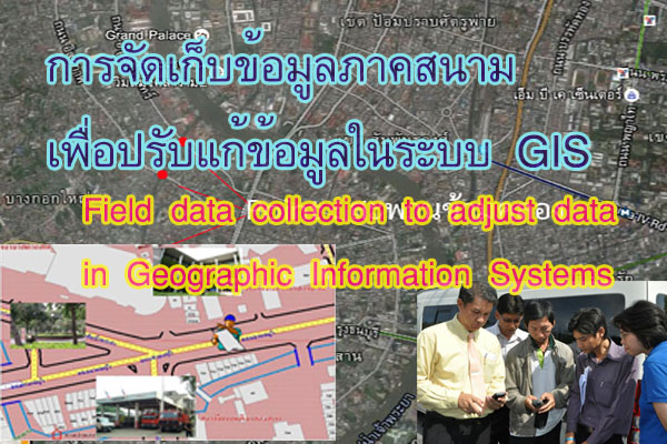
การสำรวจข้อมูลภาคสนามโดยใช้แผนที่เพื่อปรับปรุงข้อมูลแผนที่ในระบบสารสนเทศภูมิศาสตร์ จำเป็นต้องพิจารณากำหนดชนิดของคุณลักษณะข้อมูล
Improving map data in geographic information systems with field data surveys using maps. We need consideration to determine the type of data feature.
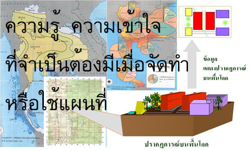
แผนที่ เป็นสิ่งที่แสดงลักษณะของพื้นผิวโลกทั้งหมด หรือบางส่วนบนพื้นราบโดยการย่อส่วนและใช้สัญลักษณ์แทนรายละเอียดต่าง ๆที่ปรากฏอยู่ สิ่งที่สำคัญที่ต้องเข้าใจคุณลักษณะของแผนที่ ประกอบด้วย
Mapping is a representation of the characteristics of the Earth's surface, either globally or in specific regions, achieved through the process of scaling down and using symbols to represent various details present on the terrain. It is crucial to understand the features of a map, which include.
1. การถ่ายทอดลักษณะของพื้นผิวโลกลงสู่พื้นราบ Transferring the characteristics of the Earth's surface to a flat plane.
2. การย่อส่วน Scaling down.
3. สัญลักษณ์ Symbols.
ดังนั้นการบันทึกข้อมูลลงบนแผนที่จึงควรเข้าใจทั้ง 3 ส่วน หลักเป็นสำคัญ สำหรับการถ่ายทอดลักษณะของพื้นผิวโลกลงสู่พื้นราบเป็นแผนที่โดยใช้สัญลักษณ์นั้น จำเป็นต้องเข้าใจเรื่องการย่อส่วน หรือมาตราส่วน เป็นสำคัญ โดย มาตราส่วน หมายถึง อัตราส่วนเปรียบเทียบระหว่างระยะทางในแผนที่กับระยะทางในภูมิประเทศจริง โดยกำหนดให้ระยะทางในแผนที่เป็น 1 หน่วย
Consequently, it is essential to grasp the importance of recording data on the map throughout all three main components. Understanding minimization or scale is essential for accurately mapping the earth's surface onto a flat map using symbols. In this context, scale represents the ratio between map distances and actual distances on the ground, with the map distance set as 1 unit.
เมื่อ มาตราส่วน 1 : 1,000 หมายความว่า ถ้าวัดระยะในแผนที่ได้ 1 หน่วย ระยะในภูมิประเทศจะเท่ากับ 1,000 หน่วย เช่น
The map scale is 1:1,000, meaning that 1 unit on the map is equal to 1,000 units on the ground. For example:
ถ้าในแผนที่เท่ากับ 1.2 นิ้ว ในภูมิประเทศจริงจะเท่ากับ 1.2 X 1,000 นิ้ว หรือ 1200 นิ้ว หรือ 100 ฟุต
If it measures 1.2 inches on the map, that's equal to 1.2 x 1,000 inches, or 1,200 inches, which is 100 feet.
ถ้าในแผนที่เท่ากับ 10 เซนติเมตร ในภูมิประเทศจะเท่ากับ 10 X 1,000 เซนติเมตร หรือ 10,000 เซนติเมตร หรือเท่ากับ 1 กิโลเมตร
If it measures 10 centimeters on the map, that's equal to 10 x 1,000 centimeters, or 10,000 centimeters, which is 1 kilometer.
การสำรวจข้อมูลภาคสนามโดยใช้แผนที่เพื่อปรับปรุงข้อมูลแผนที่ในระบบสารสนเทศภูมิศาสตร์ จำเป็นต้องพิจารณากำหนดชนิดของคุณลักษณะข้อมูล
การปรับปรุงข้อมูลแผนที่ในระบบสารสนเทศทางภูมิศาสตร์ด้วยการสํารวจข้อมูลภาคสนามโดยใช้แผนที่ เราจําเป็นต้องพิจารณาเพื่อกําหนดประเภทของคุณสมบัติข้อมูล ซึ่งชนิดของคุณลักษณะข้อมูล (Feature Type) ในภูมิประเทศที่จะนำเข้าสู่ระบบแผนที่ทั้งที่เป็น Hard Copy หรือ Digital Map เบื้องต้นสามารถจำแนกได้เป็น 3 ลักษณะหลัก คือ
Improving map data in geographic information systems with field data surveys using maps. We need consideration to determine the type of data feature. The feature type in the country that will be imported into the mapping system, whether in hard copy or digital map format, can be categorized into three main types.
1. ข้อมูลแสดงตำแหน่ง (Point) : เป็นข้อมูลที่ไม่มีขนาดความกว้าง ยาว
Positional Data (Point): Data without dimensions of width and length.
2. ข้อมูลแสดงเส้นทาง (Line) : เป็นข้อมูลที่มีความยาว และทิศทาง
Route Data (Line): Data with both length and direction.
3. ข้อมูลแสดงพื้นที่ (Area / Polygon) : เป็นข้อมูลที่มีทั้งขนาด ความกว้าง และความยาว
Area Data (Area/Polygon): Data with dimensions of width, length, and area.
การนำข้อมูลดังกล่าวแสดงในพื้นที่จำเป็นต้องพิจารณาเปรียบเทียบกับขนาดหรือมาตราส่วนของแผนที่ฐานที่ต้องการนำมาแสดงผลหรือใช้งาน เช่น เมื่อใช้แผนที่ฐานหรือแผนที่ที่ต้องการพิมพ์แสดงผลมาตราส่วน 1 : 1,000 ต้องการลงข้อมูล มีวิธีการพิจารณากำหนด ชนิดของคุณลักษณะข้อมูล (Feature Type) ดังนี้
When presenting data in each area, it is necessary to consider comparing it with the size or scale of the base map intended for display or use. For example, when using a base map or map intended for printing with a scale of 1:1,000, determining the feature type is crucial. Here are considerations for feature types when entering data:
1. ตู้โทรศัพท์ ควรกำหนดชนิดของข้อมูล (Feature Type) เป็น Point เนื่องจากขนาดตู้โทรศัพท์จริง กว้าง ยาวประมาณด้านละ 1.5 เมตร ถ้ากำหนดชนิดของข้อมูลเป็น Polygon จะต้องวาดรูปตู้โทรศัพท์ในแผนที่ กว้าง ยาวด้านละ 1.5 มิลลิเมตร (ระยะในแผนที่ 1 มิลลิเมตร = 1 เมตร) ซึ่งไม่สามารถวาดใกล้เคียงตำแหน่งจริงได้
Telephone Booths: we should set the feature type as Point because the actual size of telephone booths is approximately 1.5 meters in both width and length. If we set the feature type as Polygon, it would require drawing the telephone booth on the map with a width and length of 1.5 millimeters (1 millimeter on the map = 1 meter in reality), making it impractical to draw near the actual location.
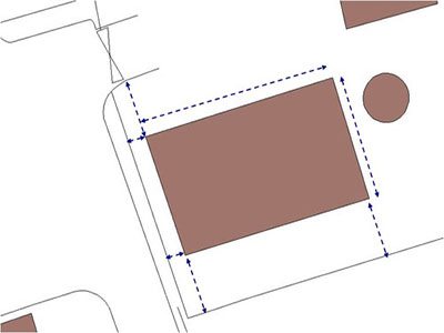
2. อาคาร ควรกำหนดชนิดของคุณลักษณะข้อมูล (Feature Type) เป็น Polygon เนื่องจาก
ขนาดอาคารจริงโดยมาก อาคารที่เล็กสุด จะมีขนาดกว้างประมาณด้านละ 4 – 6 เมตร ซึ่งสามารถวาดรูปอาคารในแผนที่ 4 มิลลิเมตรได้ ใกล้เคียงขนาดจริง จึงไม่ควรกำหนดชนิดของคุณลักษณะข้อมูล (Feature Type) เป็น Point
Buildings: we should set the feature type as Polygon because most buildings have dimensions, typically ranging from 4 to 6 meters in width. Drawing the building on the map with a width of 4 millimeters is practical and approximates the actual size, so it is not advisable to set the feature type as Point.
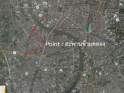
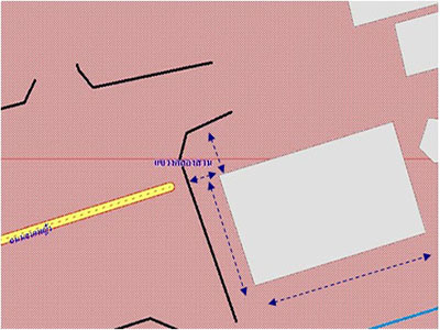
3. สะพานข้ามคลอง ควรกำหนดชนิดของคุณลักษณะข้อมูล (Feature Type) เป็น Line เนื่องจาก
ขนาดสะพานข้ามคลองจริงโดยมากจะมีความกว้างและความยาว โดยขนาดของความยาวสะพานโดยรวม มักจะยาวกว่า 5 เมตร ซึ่งสามารถวาดรูปสะพานในแผนที่ 5 มิลลิเมตรได้ ขณะที่ความกว้างของสะพานข้ามคลอง ส่วนที่เล็กสุดอาจจะกว้างเพียง 1 – 2 เมตร เมื่อวาดในแผนที่จะต้องวาดขนาดความกว้างเพียง 2 มิลลิเมตรซึ่งเป็นไปได้ยาก จึงไม่ควรกำหนดชนิดของคุณลักษณะข้อมูล (Feature Type) เป็น Polygon แต่โดยปกติ สะพานข้ามคลองจะแสดงความยาวของสะพาน และทิศทางที่ขวางลำคลอง จึงควรกำหนดชนิดของคุณลักษณะข้อมูล (Feature Type) เป็น Line
Bridge over the canal: we should set the feature type as Line because the Bridge over the canal has a substantial length and width. The total length of a bridge is often more than 5 meters, allowing it to be drawn on the map with a width of 5 millimeters. While the smallest width of a canal cross bridge is maybe 1 to 2 meters, drawing it on the map with a width of 2 millimeters is challenging. Therefore, it is not recommended to set the feature type as Polygon. Usually, the bridges over the canal are represented by their length and the direction they span the canal, making it appropriate to set the feature type as a Line.
อย่างไรก็ตาม ถ้าแผนที่ฐานหรือแผนที่ที่ต้องการพิมพ์แสดงผลมาตราส่วน 1 : 10,000 แล้ว การกำหนดชนิดของคุณลักษณะข้อมูล (Feature Type) สะพานข้ามคลองควรกำหนดเป็น Point เนื่องจากในแผนที่มาตราส่วน 1 : 10,000 จะแสดงสะพานข้ามคลองได้เพียงตำแหน่งสะพานเท่านั้น (สะพานความยาว 5 เมตร แสดงในแผนที่ 1 : 10,000 ได้เพียง 0.5 มิลลิเมตรเท่านั้น)
However, if the base map or map intended for printing has a scale of 1:10,000, specifying the feature type for the Bridge over the canal as a Point is advisable. In a 1:10,000 scale map, representing a 5-meter bridge length would only be 0.5 millimeters on the map.
หลักการเบื้องต้นเกี่ยวกับการจัดเก็บข้อมูลภาคสนามด้วยแผนที่ Basic principles regarding field data collection with maps.
เมื่อกำหนดลักษณะชนิดของคุณลักษณะข้อมูล (Feature Type) ได้แล้ว การจัดเก็บข้อมูลภาคสนามมีขั้นตอนดำเนินการดังนี้
Once the feature type of the data has been determined, the field data collection process involves the following steps:
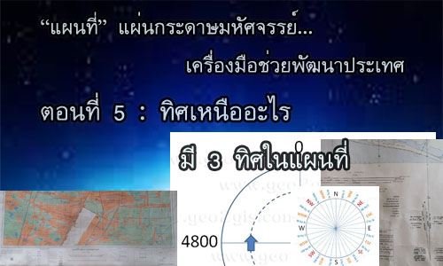
1. วางตำแหน่งทิศของแผนที่ให้ถูกต้องตามทิศของภูมิประเทศจริง ดังนี้
Accurately orienting the map's position according to the true geographical direction, as follows:
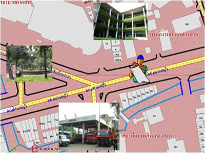
1.1 ถ้าแผนที่มีสัญลักษณ์ ทิศเหนือ ให้ทำการเทียบทิศทางกับทิศทางในภูมิประเทศจริง
แล้ววางแผนที่ให้ถูกทิศทาง
If the map has a compass symbol indicating the north, correctly align the map according to the true geographical direction.
1.2 กรณีแผนที่ไม่สมบูรณ์และไม่ได้แสดงสัญลักษณ์ทิศเหนือไว้ ผู้ใช้แผนที่ควรสังเกต
ลักษณะภูมิประเทศจริงเปรียบเทียบกับสัญลักษณ์ที่ปรากฏในแผนที่อย่างน้อย 3 จุด เช่น ในภูมิประเทศจริง ที่ตั้งสำนักงานเขตอยู่ด้านขวา สถานีดับเพลิงอยู่ด้านซ้ายมือ และโรงพยาบาลอยู่ด้านหน้าของผู้ใช้แผนที่ ให้สมมุติว่าผู้ใช้แผนที่ยืนอยู่บนแผนที่แล้ว ที่ตั้งสำนักงานเขตอยู่ด้านขวา สถานีดับเพลิงอยู่ด้านซ้ายมือและโรงพยาบาลอยู่ด้านหน้าของผู้ใช้แผนที่ด้วยเช่นกัน หลังจากนั้นจึงเขียนสัญลักษณ์ทิศเหนือลงในแผนที่ กรณีที่ไม่ทราบทิศทางในภูมิประเทศผู้ใช้แผนที่สามารถสังเกตดวงอาทิตย์ในช่วง เช้า หรือเย็น ซึ่งจะทำให้ทราบทิศว่าเป็นทิศตะวันออกหรือตะวันตกได้โดยประมาณ จากนั้นผู้ใช้แผนที่สามารถเขียนสัญลักษณ์ทิศเหนือโดยประมาณลงในแผนที่ได้จาก การยืนให้ด้านขวามืออยู่ด้านทิศตะวันออก ซ้ายมืออยู่ด้านทิศตะวันตกซึ่งด้านหน้าก็จะเป็นทิศเหนือแล้วสมมุติจุดยืน เหมือนข้างต้นและหมุนแผนที่ให้ตรงลักษณะภูมิประเทศจริงแล้วจึงเขียนทิศเหนือ บนแผนที่เพื่อเป็นจุดสังเกตต่อไป
With an incomplete map without a compass symbol, users should observe the actual geographical features and compare them with at least three points on the map. For example, if the district office is to the right, the fire station is to the left, and the hospital is in front of the map user, the user should assume their standing position on the map. If the district office is to the right, the fire station is to the left, and the hospital is in front, the user can then draw the north symbol on the map. Where the actual direction is unknown, users can observe the sun in the morning or evening to approximate east or west. The user can then draw an estimated north symbol on the map by standing with the right-hand facing east and the left-hand facing west, and the front will be considered north.
2. หาตำแหน่งบนแผนที่ที่ผู้ใช้แผนที่ยืนอยู่ โดยเริ่มจากลักษณะที่ปรากฏบนภูมิประเทศอย่างน้อยๆ 3 จุด ทางด้านซ้าย ด้านขวา และด้านหน้าหรือด้านหลังของผู้ใช้แผนที่ แล้วจึงเทียบเคียงกับลักษณะที่ปรากฏบนแผนที่
After that, the user can find three points on the map that correspond to the left, right, and front or back of their standing position, and compare them with the actual geographical features.
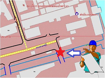
3. บันทึกข้อมูลในภูมิประเทศลงบนแผนที่ การบันทึกข้อมูลลงในแผนที่โดยทราบสัดส่วนหรือมาตราส่วนของแผนที่สามารถทำได้ โดยง่าย ซึ่งมีหลักการเบื้องต้นของการเก็บบันทึกข้อมูลดังนี้
Recording data in the field onto a map. The process of recording data on a map, with knowledge of the scale or proportion of the map, can be easily accomplished. There are basic principles for data recording as follows:
3.1 เมื่อทราบมาตราส่วนของแผนที่ Know the map scale:
- คำนวณระยะใน 1 หน่วยแผนที่เทียบกับระยะจริงบนภูมิประเทศ เช่น แผนที่ที่ใช้อ้างอิงจัดเก็บข้อมูลมีมาตราส่วน 1 : 1,000 หมายความว่า 1 เซนติเมตร เท่ากับ 100 เมตร
Calculate the distance in 1 map unit compared to the actual distance on the ground. For example, if the reference map used for data collection has a scale of 1:1,000, it means that 1 centimeter on the map is equivalent to 100 meters.
- หาตำแหน่งอ้างอิงและทิศทางในแผนที่
Identify reference points and directions on the map.
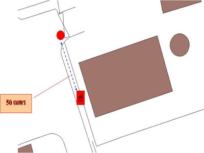
- ลงตำแหน่งข้อมูล เช่น เมื่อลงตำแหน่งตู้โทรศัพท์ซึ่งอยู่ห่างจากทางแยกประมาณ 50 เมตร โดยอาจจะวัดระยะด้วยเทปหรือการนับก้าวระหว่างจุดสนใจกับจุดที่ปรากฏในแผนที่
Position the data, for example, when positioning a telephone booth about 50 meters away from the intersection, which may measure the distance by tape or the step between the points of interest and the points shown on the map.
3.2 เมื่อไม่ทราบมาตราส่วนของแผนที่ Unknown map scale:
หาระยะอ้างอิงในแผนที่และในภูมิประเทศที่ทราบระยะจริง เช่นความยาวของถนนที่ เข้าอาคารสำนักงานประมาณ 100 เมตร เทียบสัดส่วนกับแผนที่ซึ่งวัดได้ยาวประมาณ 1 เซนติเมตร จะได้มาตราส่วนโดยประมาณ คือ 1 เซนติเมตร: 100 เมตร หรือ 1 เซนติเมตร : 100 x 100 เซนติเมตร นั่นคือแผนที่มีมาตราส่วนโดยประมาณเท่ากับ 1 : 10000
Determine the reference distance on the map and in the known actual distance. For example, the length of the road leading to the office building is approximately 100 meters, compared to a map that measures about 1 centimeter. The estimated scale would be 1 centimeter: 100 meters or 1 centimeter: 100 x 100 centimeters. This means that the map has an approximate scale of 1:10,000.
ลงตำแหน่งข้อมูลเช่นเดียวกับกรณีทราบมาตราส่วนของแผนที่ข้างต้น
Record the data position as in the case where the scale of the map is known.
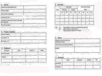
4. บันทึกรายละเอียดข้อมูลตามแบบบันทึกที่เตรียมไว้
Record details of the information according to the prepared recording format.
อย่าง ไรก็ตาม เทคโนโลยีที่ทันสมัยในปัจจุบัน สามารถลดเวลาในการสำรวจเพื่อจัดทำข้อมูลในระบบ GIS ได้ แต่วิธีการคำนวณที่ถูกซ้อนอยู่ในเทคโนโลยีอาจจะทำให้ผู้ใช้ไม่รู้ว่าข้อมูลที่ได้มาคลาดเคลื่อนเกินกว่าที่จะ นำไปใช้งาน
However, in today's modern technology, It is possible to reduce exploration time to create data in the GIS system, but the calculation methods that are stacked in the technology may cause users to not know that the data obtained is too inaccurate to be used.