


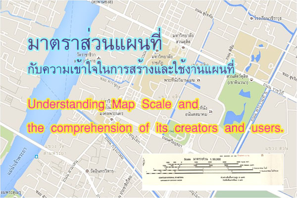


การนำข้อมูลดังกล่าวแสดงในพื้นที่จำเป็นต้องพิจารณาเปรียบเทียบกับขนาดหรือมาตราส่วนของแผนที่ฐานที่ต้องการนำมาแสดงผลหรือใช้งาน เช่น เมื่อใช้แผนที่ฐานหรือแผนที่ที่ต้องการพิมพ์แสดงผลมาตราส่วน 1 : 1,000 ต้องการลงข้อมูล มีวิธีการพิจารณากำหนด ชนิดของคุณลักษณะข้อมูล (Feature Type) ดังนี้
When presenting data in each area, it is necessary to consider comparing it with the size or scale of the base map intended for display or use. For example, when using a base map or map intended for printing with a scale of 1:1,000, determining the feature type is crucial. Here are considerations for feature types when entering data:
1. ตู้โทรศัพท์ ควรกำหนดชนิดของข้อมูล (Feature Type) เป็น Point เนื่องจากขนาดตู้โทรศัพท์จริง กว้าง ยาวประมาณด้านละ 1.5 เมตร ถ้ากำหนดชนิดของข้อมูลเป็น Polygon จะต้องวาดรูปตู้โทรศัพท์ในแผนที่ กว้าง ยาวด้านละ 1.5 มิลลิเมตร (ระยะในแผนที่ 1 มิลลิเมตร = 1 เมตร) ซึ่งไม่สามารถวาดใกล้เคียงตำแหน่งจริงได้
Telephone Booths: we should set the feature type as Point because the actual size of telephone booths is approximately 1.5 meters in both width and length. If we set the feature type as Polygon, it would require drawing the telephone booth on the map with a width and length of 1.5 millimeters (1 millimeter on the map = 1 meter in reality), making it impractical to draw near the actual location.
2. อาคาร ควรกำหนดชนิดของคุณลักษณะข้อมูล (Feature Type) เป็น Polygon เนื่องจาก
ขนาดอาคารจริงโดยมาก อาคารที่เล็กสุด จะมีขนาดกว้างประมาณด้านละ 4 – 6 เมตร ซึ่งสามารถวาดรูปอาคารในแผนที่ 4 มิลลิเมตรได้ ใกล้เคียงขนาดจริง จึงไม่ควรกำหนดชนิดของคุณลักษณะข้อมูล (Feature Type) เป็น Point
Buildings: we should set the feature type as Polygon because most buildings have dimensions, typically ranging from 4 to 6 meters in width. Drawing the building on the map with a width of 4 millimeters is practical and approximates the actual size, so it is not advisable to set the feature type as Point.
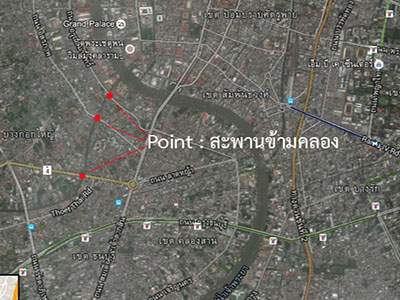
3. สะพานข้ามคลอง ควรกำหนดชนิดของคุณลักษณะข้อมูล (Feature Type) เป็น Line เนื่องจาก
ขนาดสะพานข้ามคลองจริงโดยมากจะมีความกว้างและความยาว โดยขนาดของความยาวสะพานโดยรวม มักจะยาวกว่า 5 เมตร ซึ่งสามารถวาดรูปสะพานในแผนที่ 5 มิลลิเมตรได้ ขณะที่ความกว้างของสะพานข้ามคลอง ส่วนที่เล็กสุดอาจจะกว้างเพียง 1 – 2 เมตร เมื่อวาดในแผนที่จะต้องวาดขนาดความกว้างเพียง 2 มิลลิเมตรซึ่งเป็นไปได้ยาก จึงไม่ควรกำหนดชนิดของคุณลักษณะข้อมูล (Feature Type) เป็น Polygon แต่โดยปกติ สะพานข้ามคลองจะแสดงความยาวของสะพาน และทิศทางที่ขวางลำคลอง จึงควรกำหนดชนิดของคุณลักษณะข้อมูล (Feature Type) เป็น Line
Bridge over the canal: we should set the feature type as Line because the Bridge over the canal has a substantial length and width. The total length of a bridge is often more than 5 meters, allowing it to be drawn on the map with a width of 5 millimeters. While the smallest width of a canal cross bridge is maybe 1 to 2 meters, drawing it on the map with a width of 2 millimeters is challenging. Therefore, it is not recommended to set the feature type as Polygon. Usually, the bridges over the canal are represented by their length and the direction they span the canal, making it appropriate to set the feature type as a Line.
อย่างไรก็ตาม ถ้าแผนที่ฐานหรือแผนที่ที่ต้องการพิมพ์แสดงผลมาตราส่วน 1 : 10,000 แล้ว การกำหนดชนิดของคุณลักษณะข้อมูล (Feature Type) สะพานข้ามคลองควรกำหนดเป็น Point เนื่องจากในแผนที่มาตราส่วน 1 : 10,000 จะแสดงสะพานข้ามคลองได้เพียงตำแหน่งสะพานเท่านั้น (สะพานความยาว 5 เมตร แสดงในแผนที่ 1 : 10,000 ได้เพียง 0.5 มิลลิเมตรเท่านั้น)
However, if the base map or map intended for printing has a scale of 1:10,000, specifying the feature type for the Bridge over the canal as a Point is advisable. In a 1:10,000 scale map, representing a 5-meter bridge length would only be 0.5 millimeters on the map.