


ภาวการณ์เกิดปรากฏการณ์ลานิญา
Phenomenon of Laniña occurrence.
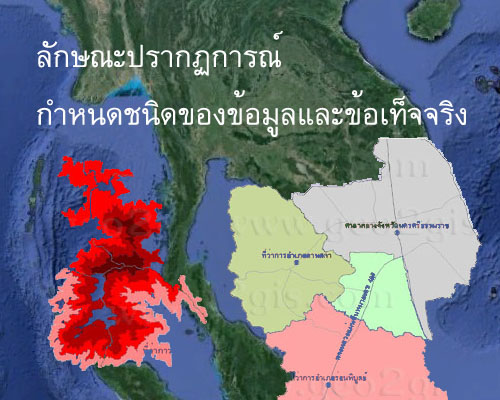
ในบางปีที่ความกดอากาศที่ระดับน้ำทะเลบริเวณตะวันออกของมหาสมุทรแปซิฟิกเขตศูนย์สูตร(ชายฝั่งตะวันตกของทวีปอเมริกาใต้แถบชายฝั่งเอกวาดอร์ เปรูและชิลี) สูงกว่าปกติ ความกดอากาศอีกฝั่งหนึ่งของมหาสมุทร (บริเวณตะวันออกและตะวันออกเฉียงใต้ของเอเชีย รวมทั้งตอนเหนือของออสเตรเลีย) ต่ำกว่าปกติ ทำให้ลมสินค้าตะวันออกเฉียงใต้มีกำลังแรงกว่าปกติ และจะพัดพาผิวน้ำทะเลที่อุ่นบริเวณชายฝั่งเอกวาดอร์ เปรูและชิลีตอนเหนือไปรวมอยู่ทางชายฝั่งแถบอินโดนีเซียและออสเตรเลียมากยิ่งขึ้น ทำให้อุณหภูมิผิวน้ำทะเลและระดับน้ำทะเลทางด้านตะวันออกของมหาสมุทรแปซิฟิกสูงกว่าปกติมาก อากาศเหนือบริเวณนี้ลอยตัวขึ้นและกลั่นตัวเป็นเมฆและฝนปริมาณมาก ส่งผลให้เกิดอุทกภัยน้ำท่วม โคลนถล่ม สร้างความเสียหายในทุกพื้นที่ทั้งพื้นที่เกษตร ที่อยู่อาศัยและอุตสาหกรรม
In some years, when the atmospheric pressure at the sea surface level in the eastern Pacific Ocean, particularly on the western coast of South America along the Equatorial Pacific region (western coast of South America along the Ecuador, Peru, and Chile), is higher than normal, and the atmospheric pressure on the opposite side of the ocean (in the eastern and southeastern parts of Asia, including the northern region of Australia) is lower than normal, the trade winds from the southeast become stronger than usual. This causes the warm sea surface waters along the western coast of South America, especially in the Equatorial Pacific region, to be pushed northward towards the Indo-Pacific region and Australia's northern areas. Consequently, sea surface temperatures and sea levels in the eastern Pacific Ocean are significantly higher than normal. The warm air over this region rises, forming clouds and heavy rainfall. This leads to an increased risk of flooding, landslides, and widespread damage to agriculture, habitats, and industries in the affected areas.

ในขณะเดียวกันด้านตะวันออกของมหาสมุทรแปซิฟิกเขตศูนย์สูตร(ชายฝั่งตะวันตกของทวีปอเมริกาใต้แถบชายฝั่งเอกวาดอร์ เปรูและชิลี) เกิดการไหลขึ้นของน้ำเย็นระดับล่างสู่ผิวน้ำเป็นไปอย่างต่อเนื่องและรุนแรง อุณหภูมิที่ผิวน้ำทะเลจึงลดลงต่ำกว่าปกติมาก ทำให้บริเวณนี้เกิดความแห้งแล้งมากกว่าปกติจนเกิดความเสียหายต่อเนื่อง
In the eastern Pacific Ocean, particularly on the western coast of South America along the Equatorial Pacific region (western coast of South America along Ecuador, Peru, and Chile), there is a persistent and intense upwelling of cold water from lower levels to the sea surface. This continuous and vigorous upwelling results in a significant decrease in sea surface temperatures, causing this region to experience much drier conditions than usual, leading to sustained and consecutive periods of drought and consequential damage.